The Edwards Aquifer and the Dangers of Overconsumption and Urbanization--Liliana Ramos, Jordan Blocker, Sneha Venkatesan
Introduction The Edwards Aquifer is a karst aquifer covering an area of approximately 4000 square miles stretching from Rio Grande River, near Del Rio, to the town of Salado in Bell County. The aquifer can be divided into three zones. The catchment zone collects rainfall and directs the water to the recharge zone, which is an unconfined section where runoff from the surface enters. Finally, there is an artesian zone that holds the water in confined fractures, conduits, and cavities until extraction (Environmental Science Institute). The unique geology of this aquifer lends itself to vulnerability due to the rapid movement and the relatively large size of the spring outlets that provide none of the filtration, absorption, and slow water flow that protect many aquifers from contamination (Clark, 1998). This potential for contamination has been set in motion by the increased urbanization in the area as city councils in Austin and San Antonio have granted millions of dollars in subsidies to developers planning on building thousands of homes, paving hundreds of acres, and generating millions of gallons of wastewater and thousands of vehicle trips per day on the Edwards Aquifer Recharge Zone.
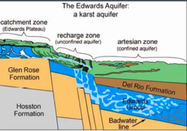
Figure 1: A diagram showing the aquifer’s different zones (Musgrove, 2000).
Contamination
Now that we have established the uniqueness of the aquifer’s hydrogeological features, we discuss how the contamination seeps through the porous formation. Urbanization is the greatest culprit behind this deterioration. As commercial and residential development grows throughout the region, the new buildings and homes introduce a variety of pollutants into the groundwater including fertilizers, pesticides,
1 cosmetics, coolants, and other waste products. This all becomes part of the watershed that eventually ends up back in our homes as drinking water.
As such, monitoring the water quality is imperative for public health and ecological purposes. The water in the aquifer is referred to as dihydrogen oxide and naturally contains ions and trace metals that can dissolve other compounds. Geological surveys track the range of ions and metals to determine how the water quality is changing. These samples are typically taken from wells in the artesian zone (Eckhardt, 1995).
Humans are not the only species who depend on the aquifer’s water quality. A variety of beetles, bats, salamanders, amphipod crustaceans, gastropod snails, and other organisms are found within several of its ecosystems, some which are endemic to the area (Eckhardt, 1995). One report by the U.S. Fish and Wildlife Service found that the Comal and San Marcos springs had the highest aquatic organism diversity in the southern United States (San Marcos/Comal Recovery Team, 1996). Some of the species classified as endangered or threatened by the U.S. Fish and Wildlife Service are the Comal Springs Riffle beetle, Peck’s Cave amphipod, Texas Blind Salamander, and Fountain Darter (Edwards Aquifer Authority, 2021).
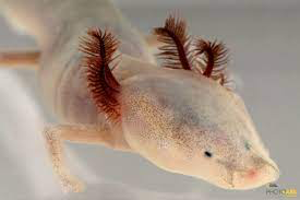
Figure 4: The Texas Blind Salamander is endemic to the San Marcos Pool of the Edwards Aquifer. Photograph by Joel Sartore (National Geographic, 2021).
Future Implications Widespread and lethal contamination has not been detected… for now. This may change as this resource becomes exploited. Currently, the only treatment required is traditional disinfection by chlorine (Eckhardt, 2021). If we want our fellow Texans to continue having access to clean drinking water, restricting further development in the recharge and contributing zones is our greatest bet. This calls for a cultural shift towards embracing a watershed ethic to protect our rights to clean resources.
For more information on the Edwards Aquifer and what we can do to help: https://aquiferalliance.org/aquifer-at-risk/
On the Trinity Aquifer: https://www.twdb.texas.gov/groundwater/aquifer/majors/trinity.asp
3 Bibliography
Clark, Allan. (1998). Vulnerability of Groundwater to Contamination, Edwards Aquifer Recharge Zone, Bexar County, Texas, 1998. U.S. Geological Survey. Retrieved from https://pubs.usgs.gov/wri/2000/4149/report.pdf
Eckhardt, Gregg. (1995). Hydrogeology of the Edwards Aquifer. The Edwards Aquifer Website. Retrieved from https://www.edwardsaquifer.net/geology.html.
Edwards Aquifer Authority. (2021). Threatened and Endangered Species protected by the Edwards Aquifer Habitat Conservation Plan. Edwards Aquifer Authority. Retrieved from https://www.edwardsaquifer.org/habitat-conservation-plan/about-eahcp/covered-species/
Environmental Science Institute. The Edwards Aquifer. University of Texas at Austin. Retrieved from https://www.esi.utexas.edu/files/EdwardsAquifer.pdf
Greater Edwards Aquifer Alliance. Aquifer at Risk. Retrieved from https://aquiferalliance.org/aquifer-at-risk/
Groundwater Foundation. Groundwater Contamination. Retrieved from https://www.groundwater.org/get-informed/groundwater/contamination.html Leopold, Aldo. (1949). A Sand County Almanac.
Musgrove, M. (2000). Temporal Links Between Climate and Hydrology: Insights from Central Texas Cave Deposits and Groundwater, unpublished Ph.D. Dissertation, University of Texas, Austin, TX, 432p.
National Geographic. (2021). Pair of Texas Blind Salamanders [Photograph by Sartore]. Retrieved from https://www.nationalgeographic.org/projects/photo-ark/animal/eurycea-rathbuni/
Nixon, Rob. (2011). Slow Violence and the Environmentalism of the Poor. Harvard University Press.
San Marcos/Comal Recovery Team, U.S. Fish & Wildlife Services (1996). San Marcos and Comal Springs and Associated Aquatic Ecosystems (Revised). Recovery Plan 6.
Texas Water Development Board. Trinity Aquifer. Retrieved from https://www.twdb.texas.gov/groundwater/aquifer/majors/trinity.asp
“Where is the Aquifer Located?”. Edwards Aquifer Authority. Online. https://www.edwardsaquifer.org/education/multimedia-library/educational-materials/where-is-the-aquiferlocated/